
Background
HiGEM is a national UK programme in ‘Grand Challenge' high resolution modelling of the global environment between NERC and the Hadley Centre of the Met Office. In a three year programme (2004-2006), the new Met Office climate model will be taken to unprecedented resolutions. This will achieve a major advance in the fidelity of simulations of the global environment, and improve our understanding of mechanisms of climate variability and change on timescales of days to centuries.
To model the global environment requires representation of the atmosphere, ocean, ice, and land surface. To do this, the earth is divided into horizontal grid boxes, these are typically 300 km square for the atmosphere and 100 km square for the ocean. However at this resolution, many processes are not properly represented, or represented at all. For example: the impact of mountains on the atmosphere; small-scale eddies in the ocean that form in regions like the gulf stream; polynyas (large cracks in sea-ice) which are sites of intense exchange between the sea and the overlying atmosphere.
The goal of HIGEM is to simulate these processes much more accurately than has hitherto been possible . Initially the HiGEM model will have a resolution of 100 km in the atmosphere and 30 km in the ocean. Subsequently the resolution of the HiGEM model will be increased to 60 km in the atmosphere, and 15 km in the ocean. 100 years of model integration will be run so that important climate processes can be studied in detail. The HiGEM model will be run on HPCx supercompter (see www.hpcx.ac.uk ) which comprises of 50 IBM POWER4+ Regatta nodes, i.e. 1600 processors, and delivers10.8 TeraFlop/s peak or 6 TeraFlops/s sustained . It is currently the most powerful computer in Europe. HiGEM will be a very large capacity job on HPCx requiring some 5000 hours processing using 256-512 processors. The HiGEM model will also be run on the Earth Simulator in Japan as part of a closely related project.
The model code itself is based on the weather forecasting model of the Met Office. It solves forms of the Navier Stokes equations and simulates the many complex processes in the atmosphere, ocean, ice and land surface. The HiGEM model integrations will produce 10s of terabytes of output and an important aspect of project is to verify this output against the latest observational measurements. The complexity of the model and huge task in analysing the output requires a multidisciplinary consortium. The HiGEM consortium (listed below) brings together a wide range of expertise including:
- Hadley Centre: Provision of new Met Office Climate Model, expert advice on climate modelling.
- Centre for Global Atmospheric Modelling: Atmospheric processes, HPC expertise.
- British Antarctic Survey: Polar processes, modelling the cryosphere.
- Centre for Ecology and Hydrology: Land surface processes and modelling .
- Environmental Systems Science Centre : Clouds and radiation processes, model evaluation against satellite data.
- Southampton Oceanography Centre: Ocean processes and modelling, remote sensing.
- University of East Anglia: Ocean processes and modelling.
- British Atmospheric Data Centre: Data management.
During the start up phase of HiGEM, which is currently underway, there is significant work developing new grids, boundary datasets, and testing of numerical solvers. It is envisaged production runs of the new high resolution model will start later in the year.
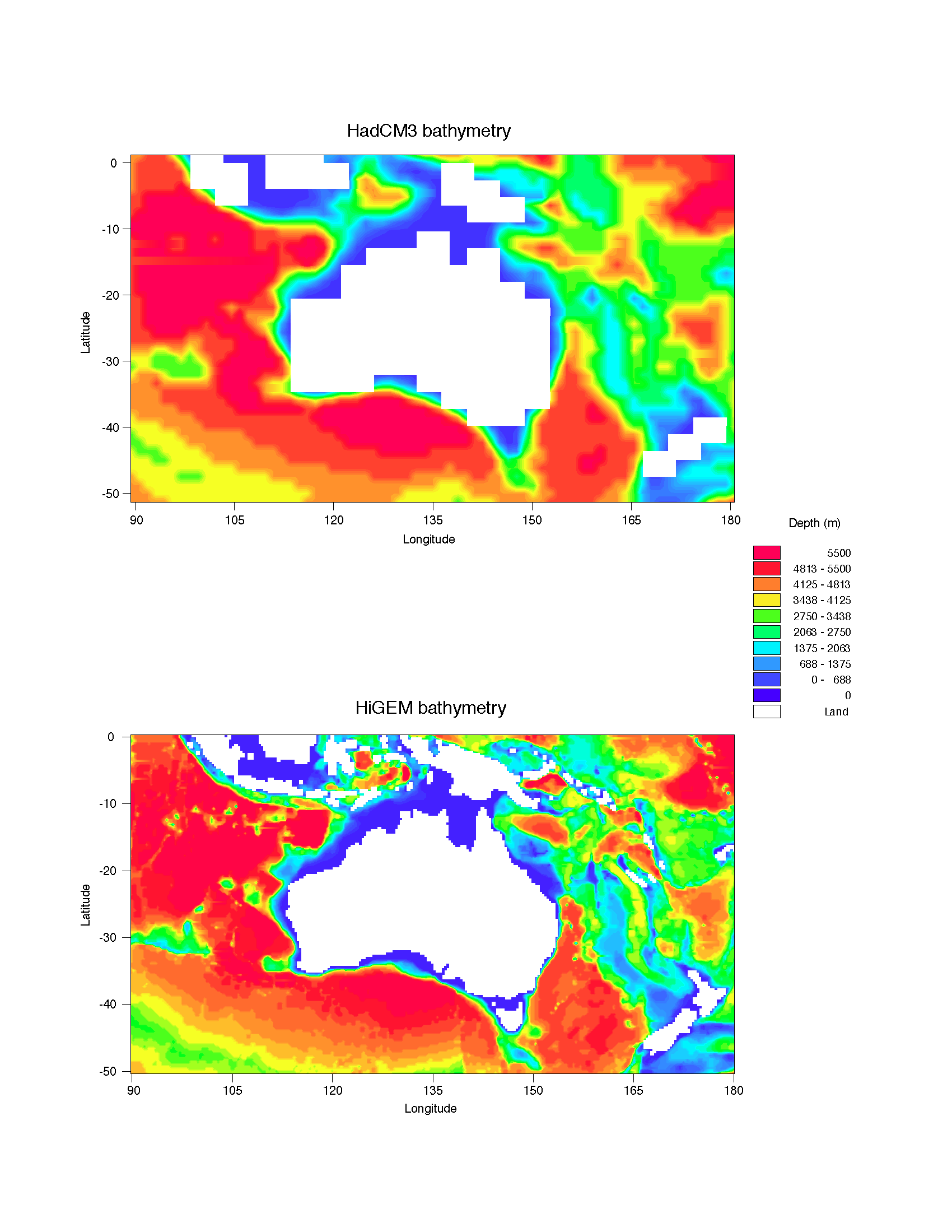
The figure shows how the representation of the ocean will change with HiGEM model compared to our current climate model (HadCM3). Shown are the ocean depths around Australia, red and oranges indicate deep ocean, blue and green shallow ocean, with white regions land. The increased horizontal resolution of HiGEM gives a much better representation of the coastlines, allows more islands, and a more accurate representation of the width of straits and channels. In this region this will allow a better representation of the passage of water through Indonesia which was poor in HadCM3 but known to be important for the global circulation of the ocean.
Other benefits of increased resolution in the ocean will include dramatic improvement in the representation of the gulf stream and the North Atlantic current. Increased resolution in the atmosphere will result in much more realistic low pressure systems and storm tracks across the North Atlantic. It is known that both the gulf stream and the storm tracks play an important role in the ocean's thermohaline circulation which releases a huge amount of heat into the North Atlantic and so warms Northern Europe. The fidelity of the simulations produced by HiGEM will provide better assessments of the likelihood of a collapse of the thermohaline circulation, a possibility that is currently receiving much public attention in the film “The day after tomorrow”.
HiGEM timeline
Over the 3 year programme (2004-2006) progressively finer model resolutions will be used:
- Hadley Centre HadGEM1 : 1.5 - 3 degree atmosphere ; 0.5 - 1 degree ocean
- HiGEM 2004: 1 degree atmosphere ; 1/3 degree ocean
- HiGEM 2006: 2/3 degree atmosphere; 1/6 degree ocean